
Historic Hurricanes Which Impacted Alabama's Coast
Ken Cooper • September 11, 2024
Historic hurricanes and their impact on our local coast

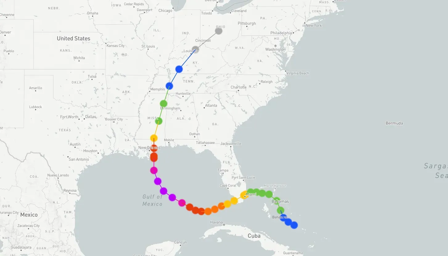
We have reached the peak of the 2024 hurricane season and there is currently a category 1 hurricane in the Gulf of Mexico forecast to make landfall in Louisiana this afternoon.
While Hurricane Francine isn’t predicted to cause any serious damage in our area, we expect to see high surf, rip currents, and potentially heavy rain. You can view
Hurricane Francine path and data
HERE.
HISTORIC STORMS:
Baldwin County has experienced the power and destruction of hurricanes and tropical storms throughout its history. From the devastating winds of Hurricane Frederic in 1979 to the relentless rainfall and slow movement of Hurricane Sally in 2020, the county has faced the full spectrum of natural disasters associated with Gulf Coast storms. Each storm has left its mark, reshaping the landscape and testing the resilience of our community.
Hurricanes such as Camille, Ivan, and Katrina brought intense wind and storm surges, while slower-moving systems like Danny and Sally caused catastrophic flooding. In some cases, such as Hurricane Opal and Tropical Storm Gordon, Baldwin County narrowly escaped the worst but still faced damage to coastal properties and infrastructure. This summary below provides an overview of several hurricanes and/or tropical storms that have impacted Baldwin County over the decades since 1969.
We could start with the Cat 3 that hit Fort Morgan on July 5th, 1916, when the pressure measured 28.38 inches (961 Mb) and landfall was made just west of Mobile. But that was before hurricanes had names, so let's take a look at the more recent ones, beginning with Hurricane Camille in 1969.
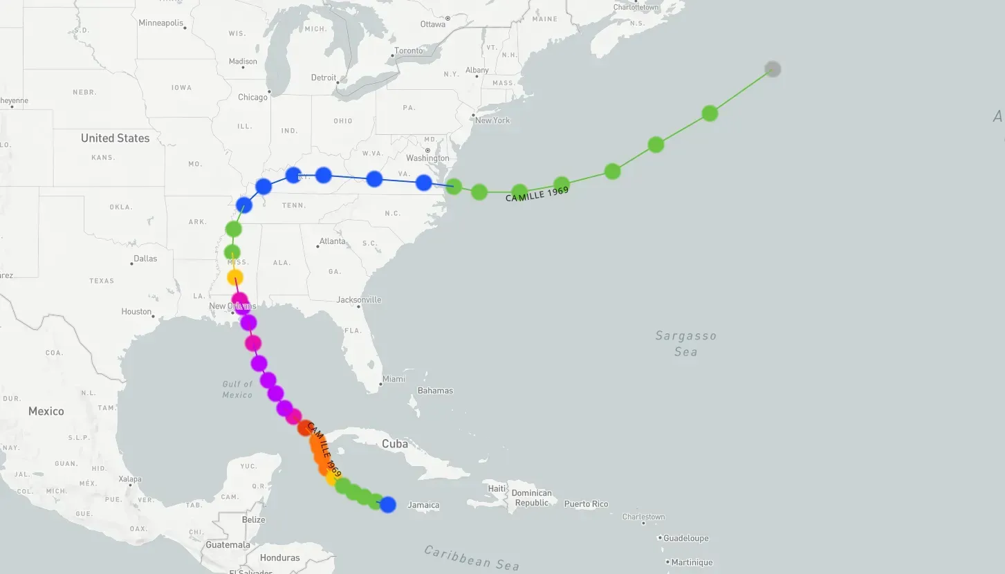
Hurricane Camille: August 17th, 1969
Hurricane Camille struck the Mississippi Gulf Coast in August 1969 as one of the most intense hurricanes to ever hit the United States. Although Baldwin County did not experience the brunt of Camille's force, it still felt significant impacts from the storm. The county experienced heavy rainfall, leading to localized flooding, and high winds caused damage to structures and downed trees and power lines. Coastal areas in Baldwin County saw storm surges that led to beach erosion and damage to coastal properties.
- Date: August 17-18, 1969
- Category at Landfall: Category 5
- Top Wind Speeds: Up to 190 mph (landfall in Mississippi)
- Rainfall: Baldwin County experienced heavy rain, though specific measurements for the county are limited; areas nearby reported up to 10 inches.
- Storm Surge: Approximately 10 feet in Baldwin County.
Hurricane Frederic: September 12th, 1979
Hurricane Frederic made landfall near Dauphin Island, Alabama, in September 1979 as a Category 4 hurricane, significantly affecting Baldwin County. The storm brought sustained winds of up to 130 mph, causing widespread structural damage, including the destruction of homes, businesses, infrastructure and the huge sand dunes. The storm surge caused extensive flooding along the coastline, particularly affecting Gulf Shores and other coastal communities. Extensive structural damage to homes and businesses, widespread power outages lasting several weeks, and significant beach erosion were experienced. Frederic caused considerable economic damage, estimated at over $2.3 billion (1979 USD), with long-term recovery efforts required.
- Date: September 12-13, 1979
- Category at Landfall: Category 4
- Top Wind Speeds: 130 mph
- Rainfall: Up to 10 inches
- Storm Surge: 8–12 feet in coastal Baldwin County, particularly affecting Gulf Shores.
Hurricane Opal: October 4th, 1995
Residents along the northern Gulf Coast woke up to alarming news on the morning of October 4, 1995. The night before, Hurricane Opal was a Category 2 storm with maximum winds of 100 mph. By 4 a.m., the storm had intensified, with winds reaching 135 mph, and by 10 a.m., Opal’s winds surged to 150 mph, just shy of Category 5 strength. This rapid escalation led to a last-minute rush of evacuations, causing gridlock on major highways like Interstate 65. Many evacuees sought refuge in local shelters as Opal approached the western Florida Panhandle.
.
According to the National Hurricane Center, Opal’s legacy will always be the devastating storm surge that occurred across the coastal areas of the western Florida Panhandle. Storm surge of 10–15 feet was recorded from Navarre Beach east to Destin with 6–8 feet observed in the inland bays from Pensacola to Choctawhatchee Bay. Opal destroyed most of the homes that were facing the Gulf of Mexico from Navarre Beach to east of Destin. In total, nearly 300 homes were destroyed with another 1,000 homes suffering major damage. Almost 1,000 boats were damaged and it was estimated that $50 million in damage was done to recreational boats. Tremendous damage occurred to the infrastructure, with water and sewer systems damaged, roads buckled, eroded, or covered in sand, and phone and electric utilities damaged. The surge destroyed Highway 399 that runs from Pensacola Beach to Navarre. U.S. Highway 98 between Fort Walton Beach and Destin was also destroyed.
To the west of Opal’s center, storm surge ranged from 4 to 7 feet from Orange Beach to Dauphin Island. This resulted in some damage to structures along the immediate coast, along with the erosion of numerous sand dunes.
- Date: October 4, 1995
- Category at Landfall: Category 3
- Top Wind Speeds: 115 mph
- Rainfall: 15.45 inches (near Pensacola)
- Storm Surge: 12–15 feet (4–7 feet from Orange Beach to Dauphin Island)
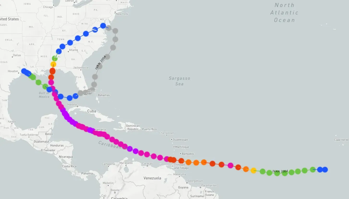
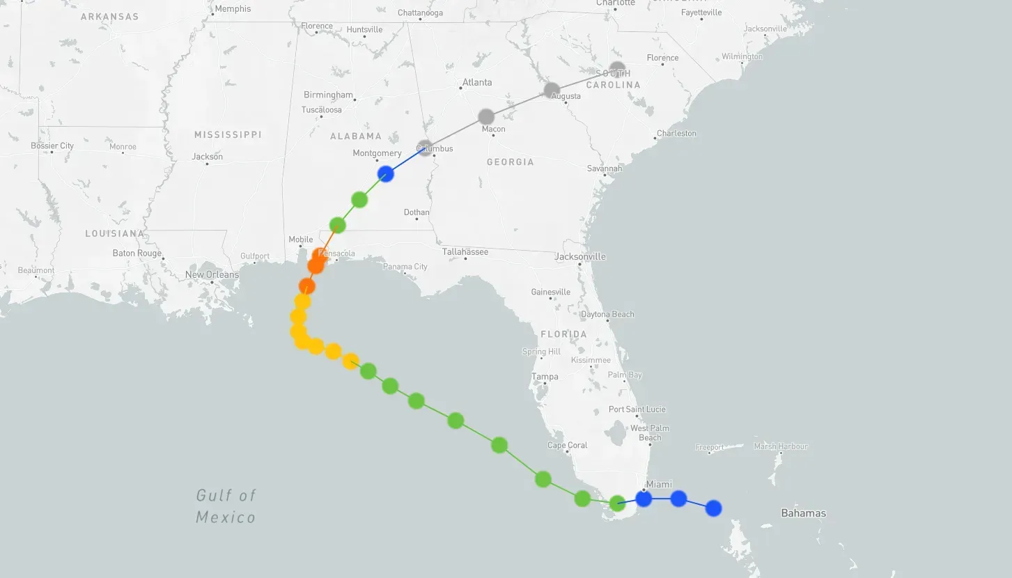
Hurricane Ivan: September 16th, 2004
Hurricane Ivan had winds around 130 mph at landfall in the United States as it moved inland near Gulf Shores. At the time, Ivan was the worst storm to strike the central Gulf Coast in 25 years. It made landfall around 1am along the Fort Morgan Peninsula. The eye traveled northward through Baldwin County, then along the Alabama River into central Alabama. The destruction was unprecedented. Homes were flattened, businesses were destroyed, and the landscape was forever changed. And while the worst damage was along the coastline of Baldwin County, it was extensive all the way north into communities such as Atmore and others as far as 100 miles inland.
Hurricane Ivan left a trail of destruction across the Caribbean and the United States. Islands like Grenada suffered catastrophic damage, with homes destroyed and vital infrastructure crippled. In the US, the storm surge and powerful winds caused widespread devastation along the Gulf Coast, particularly in Alabama and Florida. Millions were left without power, and the economic impact was immense. While Ivan wasn't the strongest hurricane to hit the region, it remains one of the costliest.
This video offers a look back at Ivan's impact on our area.
- Date: September 16, 2004
- Category at Landfall: Category 3
- Top Wind Speeds: 120 mph
- Rainfall: 4–10 inches
- Storm Surge: 10–13 feet
Hurricane Katrina: August 29th, 2005
Registered as one of the costliest and deadliest storms in the US, Katrina is most associated with destruction in Louisiana and Mississippi, but Baldwin County still felt the effects of this colossal storm. Many homes were engulfed by Katrina's surge in Bayou La Batre, while major beach erosion affected areas all the way from Dauphin Island to east of Destin. The west end of Dauphin Island was completely underwater with most of the homes washed away. At the time of landfall, hurricane force winds extended up to 125 miles east, stretching well into Baldwin County and into the Florida panhandle, causing widespread damage along the Gulf Coast.
Hurricane Katrina made landfall as a Category 3 storm. It first made landfall near Buras-Triumph, Louisiana, with sustained winds of 125 mph (201 km/h) and a central pressure of 920 mbar (27 inHg) on August 29, 2005. It then made a second landfall near the Louisiana-Mississippi border with sustained winds of 120 mph (190 km/h).
Date: August 29, 2005- Category at Landfall: Category 3
- Top Wind Speeds: 125 mph
- Rainfall: 8–12 Inches
- Storm Surge: The highest recorded surge was in Mississippi, with areas like Bay St. Louis and Pass Christian experiencing a surge of up to 28 feet (8.5 meters) above normal tide levels.
Hurricane Sally: September 16th, 2020
Hurricane Sally made landfall in the Gulf State Park in September 2020 as a Category 2 hurricane, bringing significant destruction to Baldwin County. The eye wall moved directly over Orange Beach City Hall. Sally’s slow movement resulted in prolonged heavy rainfall, leading to catastrophic flooding in many areas. Coastal areas experienced severe storm surge and beach erosion, particularly affecting Gulf Shores, Orange Beach and Perdido Key. The slow movement combined with high winds caused widespread damage to homes, businesses, and infrastructure, and power outages were extensive. The recovery process was lengthy, with substantial federal and state assistance required to aid in rebuilding efforts.
- Date: September 16, 2020
- Category at Landfall: Category 2
- Top Wind Speeds: 105 mph
- Rainfall: 10–30 inches, with the highest amounts recorded in central and northern Baldwin County
- Storm Surge: 4–7 feet, with some areas experiencing up to 10 feet
While we are currently in the peak of hurricane season remember to check in on a storm's status often. Many can quickly ramp up wind speeds or change directions. Our city governments have great experience in these matters and post bulletins often when a storm is in the area.


Recent Posts