
Idalia Landfall: View Winds And Live Radar
Ken Cooper • August 29, 2023
Hurricane Idalia Update
Idalia strengthened into a hurricane early Tuesday and is forecast to intensify quickly into an extremely dangerous major hurricane before making landfall over Florida's Gulf Coast Wednesday, the National Hurricane Center says.
Governor Ron DeSantis said in a news conference on Monday that the hurricane will likely become a Category 3 storm and he had placed over 1,000 National Guard troops on standby.
Local electrical crews from Riviera Utilities have already left Baldwin County and are proceeding to a staging area near Gainesville, Florida.
Here is the latest from the National Weather Service:
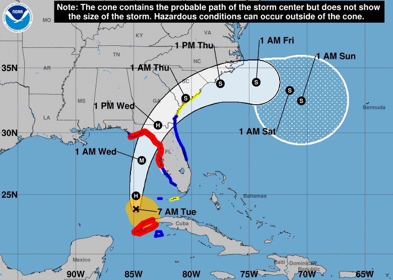
At 700 AM CDT (1200 UTC), the center of Hurricane Idalia was located
near latitude 23.8 North, longitude 84.8 West. Idalia is moving
toward the north near 14 mph (22 km/h). A northward motion is
expected today, followed by a faster north-northeast motion later
today and Wednesday. On the forecast track, the center of Idalia is
forecast to move over the eastern Gulf of Mexico today, reach the
Gulf coast of Florida within the Hurricane Warning area on
Wednesday, and move close to the Carolina coastline on Thursday.
Data from a NOAA Hurricane Hunter aircraft indicate that maximum
sustained winds have increased to near 80 mph (130 km/h) with higher
gusts. Rapid intensification is likely through landfall, and Idalia
is forecast to become an extremely dangerous major hurricane before
landfall on Wednesday.
Hurricane-force winds extend outward up to 15 miles (30 km) from
the center and tropical-storm-force winds extend outward up to 160
miles (260 km).
The minimum central pressure based on dropsonde data is 977 mb
(28.85 inches).
Portions of the west coast of Florida, the Florida Panhandle,
southeast Georgia and the eastern Carolinas: 4 to 8 inches from
today into Thursday. Isolated higher totals of 12 inches possible,
primarily near landfall in northern Florida.
This rainfall may lead to flash and urban flooding, and landslides
across western Cuba.
Areas of flash and urban flooding, some of which may be locally
significant, are expected across portions of the west coast of
Florida, the Florida Panhandle, and southern Georgia today into
Wednesday, spreading into portions of the eastern Carolinas
Wednesday into Thursday.
SURF: Swells generated by Idalia are affecting portions of the
southern coast of Cuba and eastern Yucatan. These swells will
spread northward along the eastern United States Gulf Coast during
the next day or two. These swells are likely to cause life-
threatening surf and rip current conditions. Please consult
products from your local weather office.
TORNADOES: A few tornadoes will be possible later day along the
west central Florida coast. The tornado threat will spread
northward into the Florida Big Bend by tonight.


Recent Posts